 JM-Weather

of people that sea of weather worriesn"Meteorological Oceanographic Information" is an app
Read more
of people that sea of weather worriesn"Meteorological Oceanographic Information" is an app
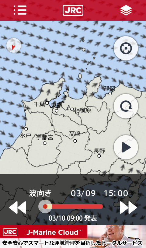
海の安全安心を提供する J-Marine アプリ 第2弾★海の天気が気になる人の「気象海象情報」アプリです!天気図の移り変わりや予想天気図及び台風情報を提供します。また,天気図や台風情報に雨量・風向風速・波高・周期・波向などの気象海象情報を重ねて表示します。更に海上警報・海上予報を表示することが可能になりました。★ゲリラ豪雨対策として「降水ナウキャスト情報」が確認できる!5分毎に更新される降水ナウキャスト情報が確認でき、陸上でご使用の方でもゲリラ豪雨対策として活用できます。【アプリ機能概要】■最新の天気図と予想天気図、台風情報を提供最新の天気図を表示します。過去の天気(1日前から現在まで)や、予想天気図(24・48時間後)を再生表示することができます。台風発生時には、台風の実況と予報を表示します。■気象海象レイヤーを重ねて表示可能「天気図」に「雨量」「降水ナウキャスト情報」「風向風速」「波高」「周期」「波向き」「海上警報」「海水温」「海流」「塩分」「海面高度」のレイヤーを重ね合わせて表示することができるため、周囲の気象海象情報を素早く把握できます。■操船時に分かりやすい「ヘッドアップ表示」が可能船上での利用を考慮した、進路方向を上に表示させる「ヘッドアップ表示」と、通常利用に最適な、北の方角を上に表示させる「ノースアップ表示」に切り替えができます。【注意事項】●気象海象データ提供元は、気象庁(一般財団法人気象業務支援センター)です。●本アプリはネットワーク通信を行います。通信が行えない場合、アプリを起動することができません。ネットワーク通信可能な場所にて起動をしてください。●本アプリは状況により、画像が乱れた状態での表示や、一部欠けた状態で表示されることがあります。その際には画面内にありますリロードボタンを押して再取得していただくようにお願いします。●本アプリは、スマートデバイス内蔵のGPS、コンパス、ジャイロセンサー、マップのパース処理などの同時利用で、CPU等に高負荷を掛け易いアプリケーションであるため、機種によっては動作が安定しない場合があります。●本アプリのヘッドアップ機能は、スマートデバイス内蔵のコンパスを利用しており、磁気を発生する機器や環境的干渉により影響を受け、正確な情報が表示されない場合があります。●本アプリは、航海用海図ではありません。●本アプリは、バッテリーを多く消費するため、予め電源供給した状態または予備バッテリー等をご用意ください。●本アプリの気象海象情報は、データ提供元の発表に合わせて随時最新の情報に更新されます。各情報の更新時間は下記の通りです。【気象海象データ更新頻度・更新時刻】各データの更新頻度・更新時刻については、アプリ内のヘルプをご覧ください。【アプリケーション情報】※対応端末Android OS 4.0以上メモリ1GB以上推奨※アプリケーションが使用する権限■アプリ内購入有料で配信している海象データを購入するアプリ内課金を含みます。■あなたの位置情報地図表示中に、自分の位置周辺へジャンプする機能にて使用します。ユーザーがこの機能を使用するとき以外では、位置取得は行いません。(位置取得中は、ジャンプボタンが赤く表示されます。この時にもう一度ボタンを押すと位置の取得を中断します。)■端末上の画像、動画、音声など設定情報の保存・読み取りに使用します。他のファイルへのアクセスは行っておりません。【利用規約】http://www.jmarinecloud.com/terms/jm_weather/terms.html【プライバシーポリシー】http://www.jmarinecloud.com/privacy.htmlJ-Marine app 2nd to provide the safety and security of sea★ It is the people that the weather of the sea is a concern, "weather oceanographic information" app!It provides a transition and forecast weather map and typhoon information of the weather map.It also displayed over the weather sea conditions information, such as rainfall, wind speed and direction, wave height, period, wave direction to the weather map and typhoons information. It is now possible to further display a sea warning and marine forecast.★ "precipitation nowcasting information" can be confirmed as a guerrilla heavy rain measures!Precipitation Nowcast information that is updated every five minutes can be confirmed, you can take advantage of as well guerrilla heavy rain measures at those who use on land.[Application function summary]■ forecast weather map with the latest weather map, provides a typhoon informationIt displays the latest weather map. (From one day before until now) past the weather and, you can play display the forecast weather map (after 24 - 48 hours). At the time of typhoon occurrence, to display the play-by-play and the forecast of the typhoon.■ piled weather walrus layer can be displayedSuperimposed layers of the "weather map", "rain", "precipitation nowcasting information", "Wind", "height", "period", "wave direction" "maritime warning," "sea temperature", "ocean current", "salt", "sea level." since it is possible to display together, you can quickly grasp the periphery of the weather oceanographic information.■ easy to understand at the time of maneuvering can "head up display"Considering the use of on board, the "heads-up display" to display the traveling direction to the above, usually best to use, you can switch to the "north-up display" to be displayed on the top of the north of direction.【Notes】● weather oceanographic data provider is the Japan Meteorological Agency (general Foundation Meteorological Business Support Center).● This app will make the network communication. If the communication can not be carried out, it will not be able to launch the app. Please refer to the start-up at the network communication possible locations.● by this application situation, display and in a state in which the image is disturbed, it may be displayed in some missing state. At that time we ask to you to re-acquire by pressing the reload button located in the screen.● This application, smart device built-in GPS, compass, gyro sensor, at the same time use, such as parsing of the map, because it is easy application multiplied by a high load on the CPU and the like, it may work depending on the model is not stable.● head-up function of this app makes use of the smart device built-in compass, affected by the equipment and environmental interference that generates a magnetic, might exact information is not displayed.● This app is not a nautical chart.● This application, in order to consume a lot of battery, please prepare in advance power supply state or spare battery and the like.● weather walrus information of this app will be updated from time to time up-to-date information to match the data provider of the announcement. Update time of each piece of information is as follows.[Meteorological oceanographic data update frequency and update time]For the update frequency and update time of each data, refer to the Help in the app.[Application Information]※ corresponding terminalAndroid OS 4.0 or higherMemory 1GB or more recommended※ authority that the application uses■ in-app purchasesIt includes in-app billing to buy the oceanographic data that is distributed for a fee.■ your position informationWhile viewing the map, it will be used in the function to jump to his position around.Except when the user to use this feature, but does not position acquisition.(In the position acquisition, will be displayed in red jump button. Suspends the acquisition of the position by pressing the button again at this time.)■ image on the terminal, video, audio, etc.Used to store and read the configuration information.Access to other files you do not do.【Terms of service】http://www.jmarinecloud.com/terms/jm_weather/terms.html【privacy policy】http://www.jmarinecloud.com/privacy.html===Ver.2.1.0 / 2.1.1===■J-Marine Cloud 運営に関連するサーバーの移行予定に伴い、アプリを更新しましたサーバー移行後はVer.2.0.1以前のバージョンではご利用ができなくなります。アプリご利用の際は、最新バージョンへのアップデートをお願いします。(Ver.2.1.1) アプリ内の一部文言を修正しました===Ver.2.0.0===■要望にお応えして機能を追加・改良しました!レイヤーの切り替えが簡単に、凡例を大きく表示する等、変更しました。■海象4種類を追加しました!海水温・海流・塩分・海面高度のデータが表示可能になりました。それぞれ14日先の予測まで表示可能です。※上記データは有料となります。■高解像度ナウキャストを正式公開しました!アンケートに回答していない方でもご覧いただけるようになりました。※詳しくはアプリ内に表示される案内をご覧ください。